Tasmania West Coast Map

West Coast of Tasmania Essential 4WD Camping Guide
The West Coast is one of the iconic regions of Australia when it comes to 4WDriving and camping.
Spectacular coastal scenery, challenging 4WD tracks, remote and stunning campsites make this area one of the premier destinations that every 4WDriver should make an effort to get to and experience for themselves.
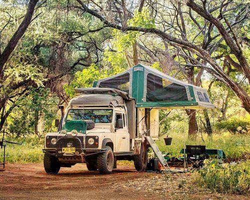
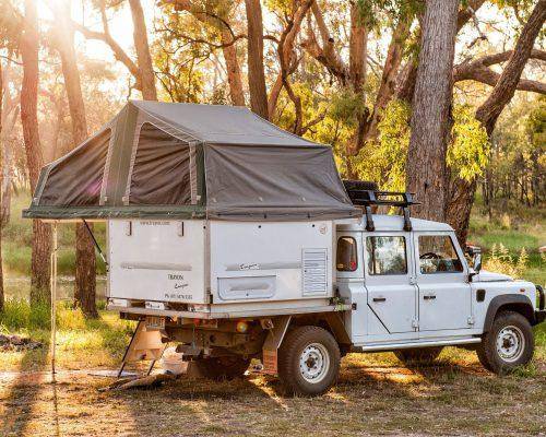
The Tassie West coast is also well-known for its wild and variable weather, but if you have a slide on camper such as the Trayon Camper you are well prepared for whatever conditions Mother Nature throws at you!
Getting to Tassie
If you are like the majority of Australian’s and live on the “big island”, the first task is to actually get yourself and your vehicle across Bass Strait. This requires booking a trip across on the Spirit of Tasmania – make sure you do this well in advance of your planned trip as places can be limited particularly if you are towing or traveling during peak times.
There are a range of accommodation options on the boat and also day; night sailings – I would suggest booking an overnight trip with a cabin so you can start off your trip rested; refreshed ready to make the most of your stay in Tasmania.

Now the vehicle fare across to Tasmania is subsidized by the government so it is pretty cheap, however if you are towing the caravan/trailer it attracts full price and can be quite expensive.
Another advantage of owning and using a tray-top camper such as the Trayon Camper!
Devonport to Arthur River
After a 10hr trip across on the Spirit you will arrive at Devonport. Head into town and stock up with supplies for the next few days from one of the many supermarkets and shops in Devonport.
From Devonport head west on the Bass Highway along the Northern coastline past many pretty towns including Burnie and Wynyard. There are plenty of opportunities to stop and explore this region further if you have time. Head past the turn-off to Stanley and its signature “nut” (distinctive rounded mountain) – another place worthy of a few days stay to explore.

Head through Smithton (a good place for any last minute supplies) and continue along the Bass Highway.
Past the Tarkine Forest and then turn left into the Arthur River road. Arthur River is just 14km further south.
Arthur River – West Coast of Tasmania
The pretty town of Arthur River has a small shop for basic supplies, a tavern for a meal or a drink, and a caravan park if wanting to stay overnight. You can even take a cruise up the Arthur River into the Tarkine
Wilderness.
Arthur River is also the gateway to this wild region of Tasmania, where the winds and sea swell lashes the western coast. The Northwest area of Tasmania is dominated by the Arthur Pieman Conservation Area, which is the name given to the area between the mighty Arthur and Pieman
Rivers.
The Arthur Pieman Conservation Area is managed by the Parks and Wildlife service, and a permit is required for access to this area. This can be
obtained from the Ranger Office at Arthur River, along with a camping permit for the days you wish to camp in the park.
The rangers will provide up-to-date information about the track conditions and are a good source of knowledge for the best campsites in the area.
Arthur Pieman Conservation Area
From Arthur River head south on the Temma Road south is a well-maintained road all the way down to Temma. There are a number of camping options off the Temma Road including Nelson
Bay, Stinking Beach and Camp Elsewhere.
Camp Elsewhere is our pick of these spots with a number of sheltered camping areas amongst the tea-tree, and usually you have this area pretty much to yourself. The beach is only a short walk across the dunes from the campsites, and the top of the dunes is a great place to watch the sun set into the ocean.
With all the luxuries of the Trayon you can camp in this fantastic place without roughing it, and even finish your day with a hot shower and a warm room with the onboard heater.


From Temma the road peters out to a rough track so air down, lock in the hubs and engage 4WD. This is now the Temma-Greens Creek Track which meanders through coastal heathlands.
There are a number of water holes along the track and the depth of these will depend on recent rains, but generally these will not cause any concern.
Approximately 5km from Temma is the infamous Balfour Track on the left, more on the Balfour Track a little later.
From the Balfour Track junction continue southwards to Greens Point where is there is a lookout that affords spectacular views up and down the coast, with the Sandy Cape lighthouse clearly in
view.
Continue down the hill to Greens Creek which is also a designated camping area and the start of the Sandy Cape Track.


Sandy Cape – West Coast of Tasmania

The track down to Sandy Cape is one of the great 4WD adventures in Tasmania with the beaches, headlands and rivers presenting a challenge that you are unlikely to find anywhere else in Australia.
However the area is wild and should not be taken lightly. The beaches are treacherous with extremely soft sand and quicksand areas, and misjudging the river crossings have claimed many
vehicles.
On average, several vehicles are lost in this area every year. Towing is not recommended so having a slideon such as the Trayon is a great advantage.
Travel with the company of at least one other vehicle, stay close together, and take particular care at the river mouths.
Generally the best course of action is to keep as close as possible to the sea and when crossing rivers, wait for the waves to recede and cross on the hard washed sand at the immediate outlet of the river.

The reward at the end of the Sandy Cape Track is the fantastic coastal views from the rocky outcrops around the lighthouse and the great remote camping.
Also there is real satisfaction and a sense of achievement at completing one of the great 4WD challenges in Tasmania and Australia.

At Sandy Cape there are two main camping areas – Sandy Cape and Pedder River.
The Pedder River campsite has the advantage of the river for swimming and dishes water, and both sites have plenty of shade and flat sites.

There is a track heading south from Sandy Cape but this only travels a few kilometers to Johnsons Head.
Access further south is only permitted under special circumstances with a permit (and key) from Parks Wildlife Service.
There is a chance that this area may be opened for 4WDing in the future, but don’t hold your breath!

After a pleasant night or two at Sandy Cape, it’s time to backtrack along the beach and then back to the Balfour Track junction.
Now is a good time to tackle the Balfour Track if continuing southwards.
Balfour Track –

The Balfour Track joins into the Western Explorer (Norfolk Road) which is the main road between Arthur River and Corinna, so after taking the Balfour Track you can head back north to Arthur River or south to Corinna and further down the west coast.
Corinna – West Coast of Tasmania
Heading south from Balfour it is only about an hour via the Western Explorer to Corinna on the Pieman River. To cross the Pieman River you need to engage the services of ‘The Fatman’ – Tasmania’s only cable-driven vehicle barge. The ferry operates on demand and charges a small fee; make sure you arrive within the designated operating hours (9am – 7pm).
There is a nice campground in Corinna if you miss the ferry or want to spend a little more time in this picturesque town.
Once across the Pieman River, continue south down the Corinna Road then turn right at Heemskirk Road before taking the Granville Harbour Road a further 10km. Now it’s only another 9km to Granville Harbour.

Granville Harbour – West Coast of Tasmania
Granville Harbour consists of several beachside houses with some good camping sites north of the settlement.
Pieman Heads can be accessed by continuing northwards, however this is a difficult track particularly the section along the Four Mile Beach. The reward is spectacular coastal scenery and some challenging driving.
Speaking of challenging driving, the trek southwards from Granville Harbour along Climies Track is one of the more difficult assignments to be faced in this area.
Climies Track starts with a steep climb from the bridge at the Tasman River through a severely rutted and clay-based section that is extremely difficult especially if recent rain has fallen. And this is just the beginning! Further along is the infamous crossing of Granite Creek at the top of a waterfall plunging straight down into the sea way below, and plenty of more challenges before reaching Trial Harbour.
An alternative is to backtrack along Granville Harbour Road to Heemskirk Road, turn right towards Zeehan and then turn right into Trial Harbour Road. This is longer but certainly the quickest route, and given the
continued deterioration of Climies Track may be a more prudent choice.

Trial Harbour is adjacent the small settlement of Remine that consists of a few holiday cottages.
There is a camping area to the north and a number of 4WD tracks to old mines in the area worth exploring if you have time.
Zeehan – West Coast of Tasmania
Back inland from Trial Harbour is the small town of Zeehan. Zeehan was known as the ‘silver city’ in its glory days in the late nineteenth century due to the large deposits of silver and lead extensively mined in the area. For more details on the area the West Coast Pioneers Memorial
museum in Zeehan is worth a visit. This museum has a range of exhibits displaying the history of west coast mining and the resilience and resourcefulness of the early pioneers.
On the outskirts of Zeehan is the Spray Mine and Tunnel, which vehicles used to be able to drive through but now is a pleasant walk. The tunnel and road leading to it formed part of a railway that was used to transport ore from the Spray Mine to the smelters in Zeehan.

Montezuma Falls – West Coast of Tasmania
Montezuma Falls is highest single fall waterfall in Tasmania (104m) and only a short drive from Zeehan. The drive into the falls is via the
old railway formation through dense rainforest and is a fantastic experience.

The narrow railway cuttings make you feel like you are fully immersed into the forest. The track has a number of challenging creek crossings and plenty of muddy sections to keep you on your toes. A lookout and suspension bridge is found at the end of the track, which allows for great viewing of the spectacular waterfall.
For an extra challenge on the way back take the Ring River Track which
commences 4km back from falls. Note that this track is very difficult with huge ruts, steep slippery sections, and dense undergrowth.

What to Take – West Coast of Tasmania
Take sufficient food, Waterproofing Canvas Tents (if needed) and drinking water for the planned duration of your trip to the North-west coast.
Supplies can be obtained at Smithton at the start and Zeehan at the end of this trip.
Basic equipment spares and recovery equipment should also be carried. There is mobile phone coverage available near Arthur River and Zeehan, but limited coverage outside these areas so alternative communication such as a satellite phone is needed and should be carried.
As this area is quite remote, consider taking a PLB or EPIRB in case of emergency.
Best Time to Visit – West Coast of Tasmania
The summer months are definitely the best time to visit this area, but be aware that wild weather can strike at any time so be prepared and flexible with your travel plans.
Conclusion
The West-Coast-4×4 of Tasmania presents many challenges to the avid 4WDriver and many difficulties are likely to be encountered. It is not an area to take lightly and comprehensive preparation is needed to tackle the more difficult tracks.
But the reward is certainly a ‘once in a lifetime’ trip full of memorable moments and spectacular scenery that is unlike anywhere else in Australia, and once completed you are likely to start planning your next trip back to this wonderful part of Australia.