Cool Camping At Coolah Tops National Park – Camping Guide
With fires still raging across much of NSW and Victoria, and communities struggling to recover from the devastation, it is hard to contemplate a camping trip. However the Australian bush will recover and the small communities need our help so please consider heading into the country and spending a few dollars at the local towns along the way. Start planning a trip for the coming months to assist the recovery.
Coolah Tops National Park Map

The Coolah Tops National Park in country NSW is not a very well-known location and is definitely off the beaten track but it is really a hidden gem. Here you can find a great free campsite with basic facilities and explore the region in your 4WD or on foot. There are also some spectacular lookouts, great forest scenery, and plenty of birds and wildlife.
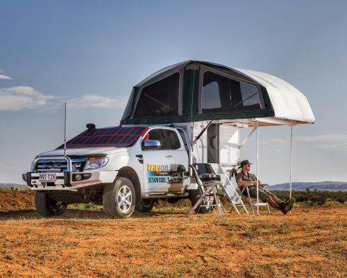
The best way to explore the region is with a slideon camper such as the Trayon. You can safely explore the numerous bush tracks without worrying about towing a trailer and the concern of turning around in tight areas. Then at camp you have all the comforts of home to best enjoy the fabulous scenery, worry-free.
Getting There
Coolah Tops is located 52km east of the small town of Coolah in country NSW which is about 56km east of Dunedoo. Coolah Tops sits at the junction of the Warrumbungle and Liverpool Ranges, with the landscape in the park consisting of tall eucalypt forests, giant grass trees, and stands of huge snow gums.
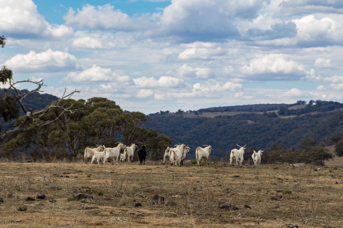
From Coolah head out on Vinegaroy Road and turn left onto Coolah Creek Road. At Coolah Creek Road there are also signposts pointing to the Coolah Tops National Park. Follow Coolah Creek Road for around 18km and turn right at State Forest Road which again has signposts pointing to the National Park. The road turns to gravel and climbs steeply up onto the ranges with great views of the Coolah Tops and surrounding ranges. The road is windy and rough in places so take care during your ascent. This is still private land with herds of cattle and lots of goats. After 14km you will come to the park entrance – take some time to read the information boards before continuing into the park.

Now there is only one way into and out of the park, but some maps will show access from the east. These tracks have been closed and gated, so make sure you plan to enter the park from the western side.
Information About Coolah Tops National Park
The Coolah Tops was gazetted as a national park in 1996 and covers an area of approximately 12,000 hectares on a narrow plateau of the Liverpool Ranges. The Gamilaraay aboriginal tribe used the area for food gathering, hunting and ceremonies before European settlement began in the area in the 1830s. Alex Cunningham first traveled through here in 1823 when he discovered Pandora Pass – the way over the Warrumbungle Ranges and onto the lush Liverpool Plains. In 1842 Ludwig Leichhardt crossed the “Tops” when he surveyed the Liverpool Range and Plains. The forests were gazetted as Timber Reserve in 1886 but it wasn’t until 1941 when the railway issued licenses allowing sleepers to be cut that the timber resources were utilized. The area was selectively logged for railway sleepers, fencing and packing timber using the abundant stringybark trees up until 1995. You can see plenty of evidence of the logging throughout the park, with old stumps with slots cut for the planks so the timber cutters could climb and fall the large trees and old machinery such as the ruins of the Cox Creek timber mill.
At the park entrance, it’s time to decide on an itinery and plan of attack. A good option is to select a camping destination and perhaps setup camp before exploring further. There are three designated camping sites – The Barracks, Cox’s Creek and The Pines campgrounds. There is also the historic Brackens Cottage that can be rented out for a small fee (bookings required in advance).
Coolah Tops National Park Campgrounds and Option
The Barracks campground is the most popular campsite and has been established on the site of an old forestry accommodation block. There is an information board, shelter shed, pit toilets, picnic tables, tank water and concrete fire rings with swing-away plates & hooks. Be sure to boil the tank water before use – there were extra wriggling items in the water when we checked! There is a short walking track (600m) to a towering stand of giant grass trees that are said to be several hundred years old and some of Australia’s oldest. The Barracks is 1km along the Pinnacle Road which is only 4km from the park entrance. If it is not busy this this would be my choice.

Cox’s Creek campground is a small area nestled among the eucalypts with pit toilets and concrete fire rings with swing-away plates & hooks. It is close to the Barrack’s (just across the Pinnacle Road) and a good option if the Barrack’s campground is busy. Adjacent is the remains of the Cox’s Creek sawmill – a reminder of the history of the area.
The Pines campground is a little further into the park – turn right into Hildegarde Road which is 5km from the entrance and follow the signs to the campground. It has a large grassy area with fire rings and pit toilets. It is well-suited for larger groups.
A short distance from the Pines Campground is the historic Brackens Cottage, a restored 1937 cattleman’s hut available for rent (organise in advance). It has a handful of wire beds but a lovely indoor fireplace that would be great on a cold winter’s night. Outside the cottage there is a picnic table, rainwater tanks, and pit toilet.
All the campgrounds will have visits from the local wildlife, particularly the grazing animals such as the wallabies and Kangaroos. There is abundant bird life and there is nothing like waking up to a chorus of birdcalls in the morning rather than an alarm clock that is usually the case at home.

There is plenty of firewood available within the park and visitors are encouraged to use the timber. This is a nice change from many of the other National Parks throughout Australia that prohibit firewood collection even though there is plenty on hand. Note that chainsaws are not permitted within the National Park.
Exploring the Coolah Tops National Park
Now once settled on a campsite it’s time to explore the park. A good place to start is to continue past the Barracks Campground to the Bundella Lookout. From the carpark it is just a short stroll to the cliff edge and the lookout – the views from the escarpment are spectacular looking across the Liverpool Plains with the volcanic peaks of the Warrumbungle Ranges in the distance.

This is the best lookout in the park and a must-see when in the Coolah Tops. Keep an eye out for the wedge-tail eagles that frequent this area riding the thermals. From Bundella Lookout it is worth taking the short walk (900m) to the Pinnacle Lookout and stand on the edge of a rocky outcrop with more spectacular views. Here you can see the escarpments steep cliffs made up of hexagonal columns of lave rock and maybe even spot the entrance to some caves that are reportedly up 60m long. If you are looking for some additional walking you can continue along Mullian Track past the Pinnacles Lookout to the Rocky Creek Falls.

From Bundella Lookout backtrack along Pinnacles Road to the main road (The Forest Road) and turn left into the Park. After 1km there is the turn on the right on Hildegarde Road which leads to the Pines Campground and other attractions – we’ll check these out later so continue along the Forest Road. The Forest Road continues for a further 26km to Breeza Lookout and Shepherds Peak, and is closed in wet conditions. These lookouts offer good views across the Liverpool Plains towards New England, but are not as spectacular as Bundella or the Pinnacles Lookouts.
About 2km back from Breeza Lookout is the carpark at the head of the Snow Gum Walk. The carpark can also be reached via a short 4WD track. This walk meanders beneath the largest known species of Snow Gum.
Coolah Tops National Park 4WD Tracks to Explore
Within the park there are a number of 4WD tracks that are worth exploring. About 9km from the Pines Campground turnoff along the Forest Road is the 4WD only track to the Talbrager River and Falls. Take the Talbragar River Trail descending through dense forest with a number of tracks to choose. Depending on your time available you can explore several of the tracks within the forest, eventually coming to the Talbrager Falls. The track continues through the forest eventually joining back onto the Forest Road. Another track worth exploring is the Bald Hill Falls track which starts just 1km south of the Pines campground and terminates at the Bald Hill Falls.

Another waterfall worth checking out is Norfolk Falls. The Norfolk Falls Road is just before the Pinnacle Road 3km from the park entrance. The walking track to the falls is short but steep descending beneath a dense canopy of silvertop stringybark, forest ribbon gum and silver wattle to reach the Norfolk Falls (35m drop). The falls are best if recent rain has fallen.
To Sum Up – Coolah Tops National Park
The Coolah Tops National Park is well off the beaten track but its remoteness adds to the appeal and your effort in getting there will be rewarded. There are some great campgrounds, spectacular views, plenty of wildlife & birds, and some 4WD tracks to explore. Take the time to head out and explore this remote piece of the NSW central ranges – you won’t be disappointed.