Canning Stock Route Map

The Canning Stock Route (CSR) is one of the most remote tracks in Australia and probably in the world. This remoteness requires a thorough degree of preparation of both your vehicle and participants as there are no towns & limited opportunities for restocking or spares. You’ll need to be completely self-sufficient. Also, it is important to travel with other like-minded travellers as it is a harsh and remote region. The reward is some spectacular scenery, incredible remote camping and a true diversity of environments you are unlikely to see anywhere else.

Like many of the 4WD destinations in Australia, the CSR has seen an increase in visitors and even operating luxury commercial tours so you are more likely to come across other groups.
Particularly in the popular areas such as Durba Springs and the major wells. Our first trip on the Canning Stock Route we only saw three other groups over two to three weeks!
However, there are many places the tours don’t go and plenty of space & opportunities to escape the crowds, particularly if you undertake some additional planning & research.
How long does the Canning Stock Route take?
For most of us, it’s a major trip just to get to the start of the CSR! The track stretches for 1850km from Wiluna in the south to its northern end at Billiluna Community on the Tanami Track. The nearest major centres are Kalgoorlie (534km south of Wiluna) and Halls Creek (174km north of Billiluna).
Most travellers tackle the CSR from south to north, but there is no distinct advantage either way. Just depends where you want to start and also where you’ll go afterwards.
The Canning Stock Route travels through three major desert regions:
- The Gibson Desert
- Little Sandy Desert
- The Great Sandy Desert.
Canning Stock Route Permits & Resources
Permits are required now to access the CSR – details and permit applications can be found on the Kuju Wangka website.
This website also has plenty of information to help you obtain permits online for your Canning Stock Route trip. Other sources of information include the following:
A great book to read before and take along on your trip is “Canning Stock Route – A Traveller’s Guide” by Ronele & Eric Gard. It is a very detailed book that will certainly assist with planning and add to the experience.
How hard is the Canning Stock Route?
Spanning over 1,800km, the Western Australia route traverses through and over three deserts, has more than 900 sand dunes to wander through – some of them higher than a three-storey building!
Taking roughly 20 – 38 days to complete it’s no small feat. Any less than that you may risk damaging your vehicle, which is the last thing you need in the middle of nowhere. Always remember to drive to the conditions.
A few adventurers have traversed the track on foot, by bicycle, and in two-wheel drive vehicles. It all depends on your idea of adventure.
The key component of this journey, and quite frankly the determining factor as to how difficult it will be, is planning. The preparation phase of the journey should have been made months in advance.
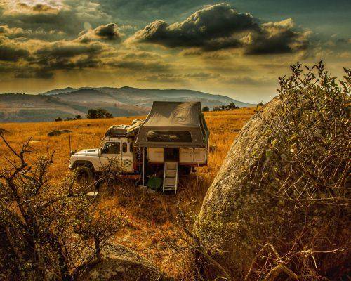
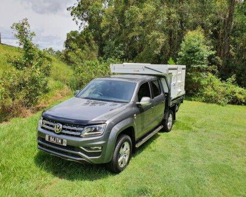
Towing of trailers and campers on the Canning Stock Route is not recommended, and the bottom section from Wiluna to Well 5, trailers are actually banned completely. Another reason for selecting a lightweight slide-on camper such as the Trayon, where you can fully experience the CSR with all the comforts and essential storage needed for such a remote trip.
The vast openness of this track means that you must bring what you’ll need for the duration. The immense swaths of extremely harsh arid terrain and distance between, resources will humble anyone not fully prepared.
Allow 20 – 28 days for your CSR trip, and carefully plan your food, water and fuel requirements for this long-distance desert travel. There is plenty of information on the various websites to help with this. Remember that excess weight can seriously compromise your vehicle particularly with the killer corrugations that are present on large sections of the track. Another reason for selecting a lightweight camping option such as the Trayon Camper.
I could go into a lot of detail on planning and preparation for this trip, but if you are contemplating a Canning Stock Route trip then you should already have some experience in remote travel and extensive outback driving experience. Of particular importance is an EPIRB/PLB and Satellite Phone – there is no mobile service and it is the longest stock route, so you need to be prepared for an emergency. We had to use our Satellite Phone on our last CSR trip due to the extremely harsh arid terrain and a vehicle breakdown. Take our word for it, it’s important.
How much fuel to carry for the Canning Stock Route
Many trek guides and online forums state that you must not rely on the supposed fuel stations along the route. Your very reliable vehicle will still consume a tonne of fuel on the intended route.
Considering the majority of the journey is heavy sand travel and high fuel consumption, notes from previous travellers state that a minimum, 400 litres to 470 litres is required for the entire trip.
How was the Canning Stock Route made?
In the early 1900s the Kimberley Cattle Stations needed a route to transport their cattle to the prosperous Western Australia goldfields. The existence of cattle ticks excluded the use of other transport methods so a stock route had to be found.
The cattlemen engaged Alfred Canning to determine a suitable route and during 1906/1907 he completed a full survey, reporting that it was indeed feasible. From 1908 to 1910 he led a team to construct the 51 wells between Halls Creek and Wiluna (a distance of 1850km). Wells were constructed one day’s travel apart for a mob of cattle to survive the long-distance desert travel because there were few or no facilities available.
Once completed there were only five mobs of cattle and three mobs of horses that used the stock route over a nineteen-year period – during this time the original wells and equipment were damaged and the Government decided in 1929 to refurbish the CSR. The first team engaged were unable to complete the task and Alfred Canning was brought out of retirement (aged 68) to do the job properly.
With the onset of WWII, there were concerns of an invasion of the Northwest so the Canning Stock Route was again refurbished in anticipation of an emergency evacuation. At the end of the war, transporting cattle south resumed and slowly the intended route fell into disrepair. It continued to be used, however, with droving parties completing rudimentary maintenance. It was used for another 14 droves from 1945 until the last being in 1959.
When a fuel dump was established at Well 23 by the Capricorn Roadhouse in the 1980s, 4WDrivers intrigued by the sandy track of the Canning Stock Route heritage and the challenging adventure across Australia’s most remote deserts began to encounter unforgiving terrain of the Canning Stock Route in greater numbers. Today, the attraction is the journey itself rather than a destination and up to 100 specifically prepared vehicles per day are known to spread out across the route during the peak season.
What kind of Flora & Fauna to expect on the CSR
You might think that a desert region full of sand dunes would be devoid of vegetation but in fact, the opposite is the case – the desert region through which the CSR traverses supports a vast range of flora and fauna.
Most common is the Spinifex which provides a habitat for a range of creatures. There is a range of trees including White Gums, Bloodwood Gums, the Desert Popular and Desert Oaks. Also prevalent are a range of flowering plants including Acacias (wattles) and various types of Grevilleas. There are grass trees with a large stand present near well 6.

Camels are common throughout the route. Even though efforts are being made to reduce their numbers and impact on the environment, you are likely to see plenty roaming about.

There is a lot of birdlife to see, particularly around the various waterholes. Expect to see Honeyeaters, Finches, Doves, Galahs, Pigeons, Budgerigars, and Parrots.
Extremely Harsh Arid Terrain
Travelling the CSR, you will encounter salt lake systems, major creeks, rocky ranges, gravel rises, sand dunes (900+) and sand plains. It is a captivating region to see if you have a very reliable vehicle (four-wheel drive vehicle). At times you will cross a sand dune and enter a completely different environment, depending on what nature has provided in the preceding season. Sometimes fire has stripped the landscape bear, then crossing the next dune you enter a lush forest of flowering shrubs and plants with amazing smells.
Suggested Itinerary and Highlights
For this trip, we will travel the CSR from south to north in a well-organised convoy.
Stock up with your major supplies at Kalgoorlie, head north to Wiluna for the final top up of fuel and groceries. Stay overnight in Wiluna or head north to start the CSR – the turn-off on the right 39km north of Wiluna. There are several camping options for your first night including well 2, which is just 2km from the main road, and tank 2A (The Granites) which is a further 36km.
As you travel north along with the CSR there are many sites to see including each of the 51 wells. Some wells have been restored and many have water suitable for use, however, make sure you treat any water you plan to consume. The suitability of many places to camp will vary depending on what travellers are already there so allow enough time to perhaps select the next place along the track. I’ll list a few places and give a stock route breadcrumb below.
Windich Springs. Great place right near a waterhole with shady gum trees. A decent Toilet is usually operational as well.

Pierre Springs (Well 6). Lovely spot with White-barked gums and clean water. Multiple spots and a toilet are available. Can be popular.

Durba Springs. This spectacular green valley with gum trees and surrounded by red cliffs is a highlight of a CSR trip. Allow a couple of nights here – time to take in the surroundings and explore up on the range. Look for aboriginal paintings, birdlife, and fantastic views across the plains. Visit Biella Spring and climb up to Cannings Cairn for more great views.

From Cannings Cairn you will see the Puntawarri Track heading west – this remote track is an option to head west to Jigalong and Newman and is well worth the effort (obtain permits online etc). Many maps do not show this track but it has quite a few travellers as well as many locals. There are some great campsites along this track, particularly near Savory Creek.
Continuing along the CSR, there is the turn-off to Diebel Spring and Diebel Hills. The spring and hills are worth the 20km detour if you have time, extensive outback driving experience and fuel – there is good camping and views.
Next is Lake Disappointment. There are a lot of camping spots along the western edge of the lake with shady sites and great views. Venture out onto the massive salt lake and look for petrified animals – we found a poor thorny devil that had succumbed to the salt & heat.
Further on from Lake Disappointment is Georgia Bore and the Talawana Track. Georgia Bore has very good water and a place to top up if needed. Good camping here too.
Talawanna Track is a major track – head westwards for the communities of Parrngurr (Rudall River) and Jigalong. East for 22km from Georgia Bore is Well 23 and the old Capricorn Roadhouse Fuel dump (used to be able to arrange fuel here).
Just before well 33 is the turnoff to Kunawarritji Community – your fuel restocks place. The store also has basic supplies if needed. Camping available here but there are better spots back along the CSR. The Kidson Track is another option if needing to head west – it heads past Telfor mine and ends up at Marble Bar.
The corrugations on the CSR near Kunawarritji are horrendous track conditions – even experienced four wheel drivers be warned!
Heading back along the CSR there are plenty of sand dune country & salt lakes to negotiate and wells to inspect.
Breaden Hills area. Another scenic area. Check out the 100 year old graffiti from explorers at Godfey Tank and Breaden Pool. Look for signs of aboriginal occupation such as grinding stones and rocks. Good camping.
A few more wells and we reach the end of the CSR when it terminates into the Tanami Road at the Billiluna Community – fuel available here from the store.
Conclusion
The Canning Stock Route is a fantastic adventure with spectacular scenery, remote camping, history to relive, and some challenging 4WDing. It is very remote and requires detailed planning and preparation but the rewards are well worth it. Start planning your trip now to this Iconic part of Australia – you will not be disappointed.