The Victoria High Country (VHC) is in the north-east section of the state and includes spectacular mountain scenery, fabulous country towns with all manner of local goods and produce, and importantly some of the best 4WD tracks and campsites in all of Australia.
The High Country has plenty of challenging tracks with many not unsuitable for camper trailers and having the freedom of a slide on camper a distinct advantage. Nothing better rocking up to one of the pristine campsites in the VHC with all the comforts of home that you have in the Trayon.
In researching your trip into the High Country there is plenty of information including road closures and warnings on the Department of Environment, Land, Water & Planning Website and Parks Victoria Website
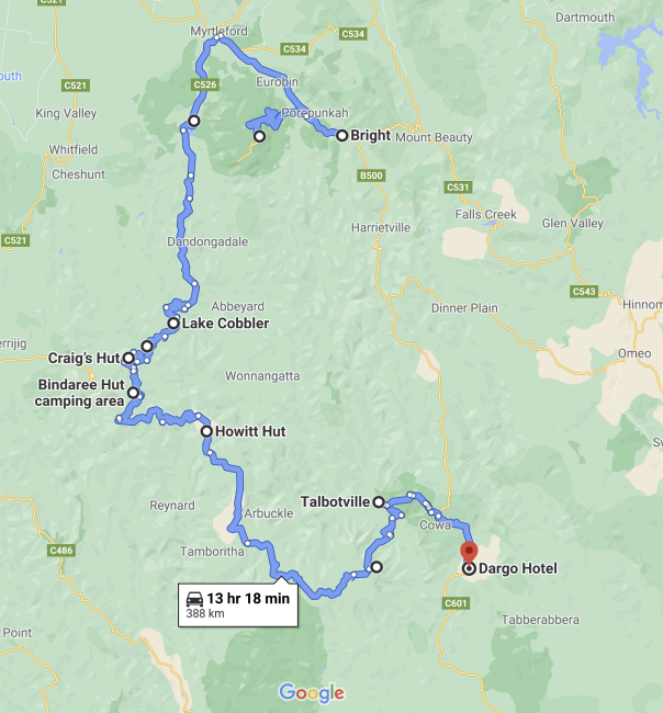
In this trip we will venture from north to south through part of the VHC, commencing at Bright and concluding at the historical town of Dargo.
Bright – The Beginning
The busy town of Bright is an ideal place to stock up with groceries and fuel, as well as perhaps sampling some of the fantastic beers at the Bright brewery.
There are plenty of accommodation options in Bright but be warned – it is busy all year round particularly during school and public holidays. Our pick for a caravan park is the NRMA Bright Holiday Park which is walking distance from the town centre with shady powered and unpowered sites.
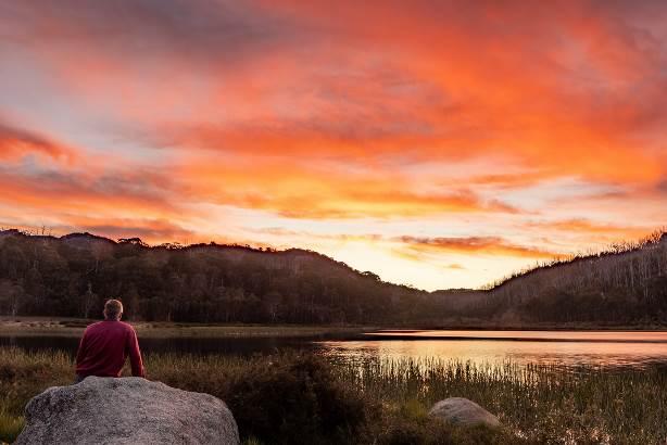
One of the main attractions close to Bright is the Mt Buffalo NP which is a great day-trip with great views to the valleys below and with towering mountains in the distance.
There are some excellent walks including the Horn, and if visiting in the summer it is well worth booking a site at Lake Catani campground – you can book via the Parks Victoria link above.
After a few days in the relatively busy areas of Bright and Mt Buffalo, we’ll head south into the High Country leaving the bitumen behind.
From the base of Mt Buffalo at Porepunkah head east to Myrtleford along the Great Alpine Road, then take the Buffalo River Road south towards Lake Buffalo. This road skirts alongside the Mt Buffalo NP with views to the mountains. The Buffalo River Road terminates at Dandongadale where there are several choices to the west, east or south.
Southwards continues to follow the Buffalo River along the Abbeyard Road where there are several formal campgrounds beside the river many with pit toilets and picnic tables, eastwards heads back around Mt Buffalo via Goldie Spur Track to the Buckland Valley, and westwards follows the Rose River via the Rose River Road. This trip we took the Rose River Road then the Upper Rose River Road onto Lake Cobbler Road to Lake Cobbler.
Lake Cobbler is unfortunately not a natural lake – it was created in the 1960s by damming a swamp area in the headwaters of the Dandongadale River.
After leaving Lake Cobbler the Dandongadale River plunges over a precipice, creating the longest drop waterfall (255m) in Victoria. You can see part of this waterfall from the Lake Cobber Road just before reaching the lake.
There are camping areas beside the lake with pit toilets and a hut nearby. There are also some walking tracks around the lake, and the track up to Mt Cobbler offers stunning high-country views towards Mt Buller and beyond.
Kings Hut
From Lake Cobbler continue southwards on Lake Cobbler Track joining Speculation Road, then then right onto King Basin Road and to King Hut.
King Hut was originally built as a slab hut and cattle yards in the early 1900s to 1920s by Jim Hearn. It had suffered over the years and was rebuilt to its current form in 2011 by volunteers. The area around the hut and further along the King River has plenty of great riverside camping areas and you shouldn’t have a problem finding your own perfect campsite (outside of the summer holiday periods).

From Kings Hut backtrack to Speculation Road and head south until it terminates into Circuit Road. Turn right and follow Circuit Road to Clear Hill Tracks – turn left and head up to Craigs Hut.
Craigs Hut is one of the most famous huts in the High Country, but it is not a cattleman’s hut and was built for the “Man from Snowy River” movie in 1981. The current hut is the third incarnation (built in 2006) after bushfires and neglect destroyed earlier versions.
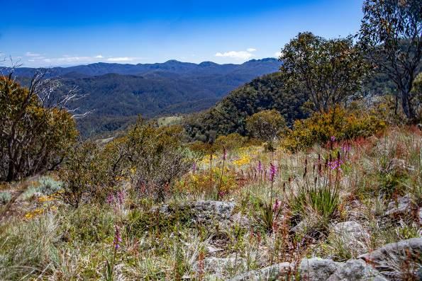
It is a stunning location with amazing views to the surrounding mountains, and it is worth spending some time here to take in the scenery. With such panoramic views it is hard to know which way to look and photograph!

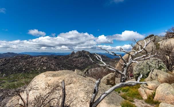
From Craigs Hut a great track to take is the Clears Hills Track which takes you right over Mt Stirling. At 1742m Mt Stirling is one of the highest peaks in the area and affords fantastic 360 degree views of the alpine area.
There are some huts to visit along the way including GGS and Howqua Gap Huts. Clear Hills Track joins Howqua Gap Track and terminates on Circuit Road at Howqua Gap.
From Howqua Gap you can head across to Mt Buller resort via Corn Hill Track, or head east along Circuit Road for 12km to Bindaree Road which is the route we took. Head right down Bindaree Road making sure you stop at Bindaree Falls which is unique since you can walk right underneath the falls.

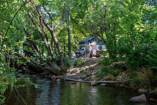
Bindaree Road terminates at the bottom of the hill at the picturesque Howqua River – there are several camping options here including the area around Bindaree Hut and Flat Spur Camping area, both with pit toilets and flat grassy campsites.

From the Howqua River head up via Bluff Link Road then Bluff Track pass Bluff and Lovicks cattlemen’s Huts.

There are fantastic views all the way along these tracks, none better than the aptly named Picture Point.
Bluff Track joins into King Billy Road then crosses the headwater of the Macalister River before climbing up to the Howitt High Plains. Call in at Howitt Hut – another iconic High Country Hut and a great place for lunch.
Howitt Road
Once up on the High Plains there are plenty of options including heading down Zeka Spur Track to Wonnangatta Station, Butcher Country or Caledonia River Tracks to the Macalister River, or continue along the Howitt Road. This time we chose the Howitt Road.
There are some great places to explore along the Howitt Road including walking tracks to Guys Hut and the Bryces Gorge Circuit, definitely call into Dimmick’s Lookout for more spectacular views.
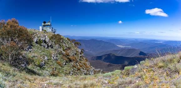
Continue south along Howitt Road to Arbuckle Junction then take the Moroka Road to the best outlook (IMO) in the Victorian High Country – Pinnacles Fire Tower. From the Pinnacles carpark it is a short walk up the access track to the radio transmitter and fire spotters hut, then a steep track with sheer drops on both sides to the fire tower.
The views are breathtaking – the panoramic 360o views from the Pinnacles take in the seemingly endless mountains and valleys to the North and the plains all the way to the sea to the South (on a clear day). With so many great lookouts and vistas right across the High Country it is a big call to pick a favorite but the Pinnacles is my choice!
Billy Goats Bluff
From the Pinnacles it is time to tackle one of the best known and often challenging Billy Goats Bluff Track.

The track is very steep (drops 1200m in less than 7km) and challenging, with rock steps and loose sections requiring prudent line selection and plenty of clearance. The track can be quite narrow in places and it can be challenging to pass oncoming vehicles so put your UHF radio to scan and keep a close watch for vehicles.
This track is doable with a camper trailer but having a lightweight slide on like the Trayon makes the experience easier and safer without sacrificing any of the camping essentials we like to have in the bush nowadays. There are some great photo opportunities all the way along the track, particularly at “the pinch” and the helipad.
At the bottom of Billy Goat Bluff track is the Wonnangatta Road. Turning left will take you through to Eaglevale and onto Wonnanngatta Station, but on this trek we’re turning right towards Dargo. Around 6km onwards is Kingswell Bridge and immediately over the bridge turn to the left onto the Crooked River Track.
Crooked River Track
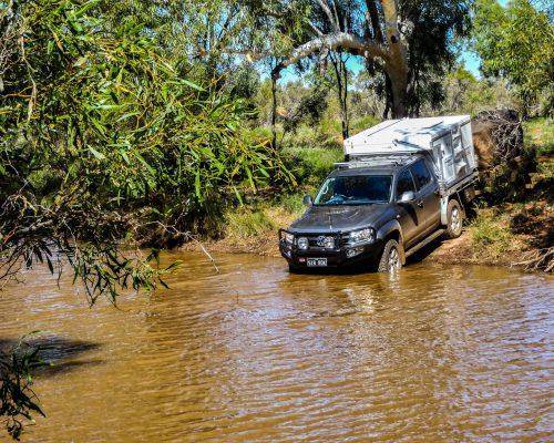
The Crooked River Track heads north through farmland and then into forested areas. There are a few deep river crossings that are generally straightforward with a firm base, however take particular caution especially if recent rains have fallen. The track eventually comes to a large open grassy area called Talbotville, a very picturesque and terrific place to camp.
From Talbotville take the McMillan Road up to Grant which is approximately 11km. The Grant Township once had a population of around 2000 with stores, hotels, a police station, churches, banks, dwellings and even a local newspaper flanking two broad main streets.
However little remains today. There are some information boards and walking tracks around the township which provide an insight into the town’s former glory.
Dargo
From Grant head 6km to the Dargo High Plains Road then turn right toward Dargo which is a further 17km away.

Dargo is arguably the hub of the High Country. There is plenty to see here including grabbing some last minute supplies, souvenirs or fuel from the general store. A fantastic option when passing through is to enjoy a meal at the legendary Dargo Pub.
The Dargo Pub has a great ambience and is a terrific place to enjoy a cool beverage and grab a meal, while taking in the various photographs and information on offer inside
Conclusion
The Victorian High Country (VHC) has some of the best 4WDriving and camping anywhere in Australia, and this trip covers some of the best in the region.
Having a tray top camper such as the Trayon allows you to safely negotiate the tough and tight tracks while experiencing all the comforts of home when camped in one of the many pristine campsites. Start planning a trip to the VHC and experience all its beauty first-hand – you will not be disappointed.